
Tiouraren Fm
Type Locality and Naming
Group/Subgroup: Irhazer Gr / Dabla Subgroup
References: Lapparent, 1960; Greigert & Pougnet, 1967; Taquet, 1976; Lefranc & Guiraud, 1990; Moody & Sutcliffe, 1991; Mateer et al., 1992; Sereno et al., 1994; Moody, 1997; Sereno et al., 1999, 2004; Guiraud et al., 2005; Rauhut & López-Arbarello, 2009; Remes et al., 2009; Mudroch et al., 2011; Le Loeuff et al., 2012; Van Damme et al., 2015; Serrano-Martínez et al., 2015, 2016; Web-04; Web-06.
Synonym: Tiouaren (misspelling); Originally included in the upper part of the “Argiles de l'Ihrazer” (Greigert & Pougnet, 1967).
Lithology and Thickness
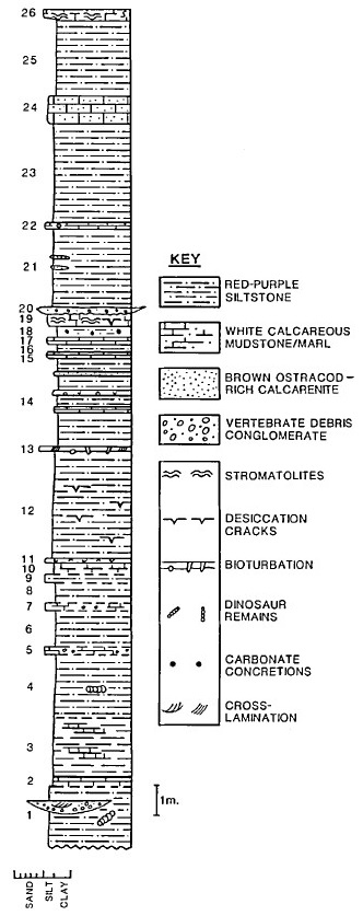
Predominantly clay-rich overbank deposits with developed paleosols and rare fluvial channels. The Tiouraren Fm is mainly made up of reddish to purple siltstones, with intercalations of marls and limestones and rare channel sandstones (Moody & Sutcliffe, 1991), although Sereno et al. (1994, p. 270, footnote 22) note that the fine-grained sediments in the area of In Gall are better understood as overbank mudstones, rather than siltstones. Stromatolites, encountered in the calcareous layers, desiccation cracks and caliche horizons – all indicators of semi-arid to arid conditions – were reported by Moody & Sutcliffe (1991). However, this could not be confirmed by Sereno et al. (1994). Moody (1997) states that it consists of a cyclic series of evenly bedded and laterally extensive siltstones, marls and freshwater limestones. Each cycle, which can vary from 1-3 m in thickness, consists of variegated red-purple-green siltstone capped by either thin calcareous siltstone or calcarenite. Planar laminae and small-scale fining-upward sequences are present throughout the Formation. The thin capping units of each cyclothem (5-30 cm) are either carbonate-rich siltstones or ostracod packstones and grainstones. Algal or fungal stromatolites are developed within specific capping rocks; they are occasionally brecciated or silicified. Desiccation cracks and pedogenic features, such as isopachous phreatic cement, caliche globules and calcite-filled rhizoids are also observed. Occasional channel sands and gravels outcrop locally, mostly toward the base of the Formation. The siltstones' fine-grained nature and extensive lateral distribution indicate a low energy fluviatile-lacustrine depositional environment. The indication is of a denuded area with little topographic variation.
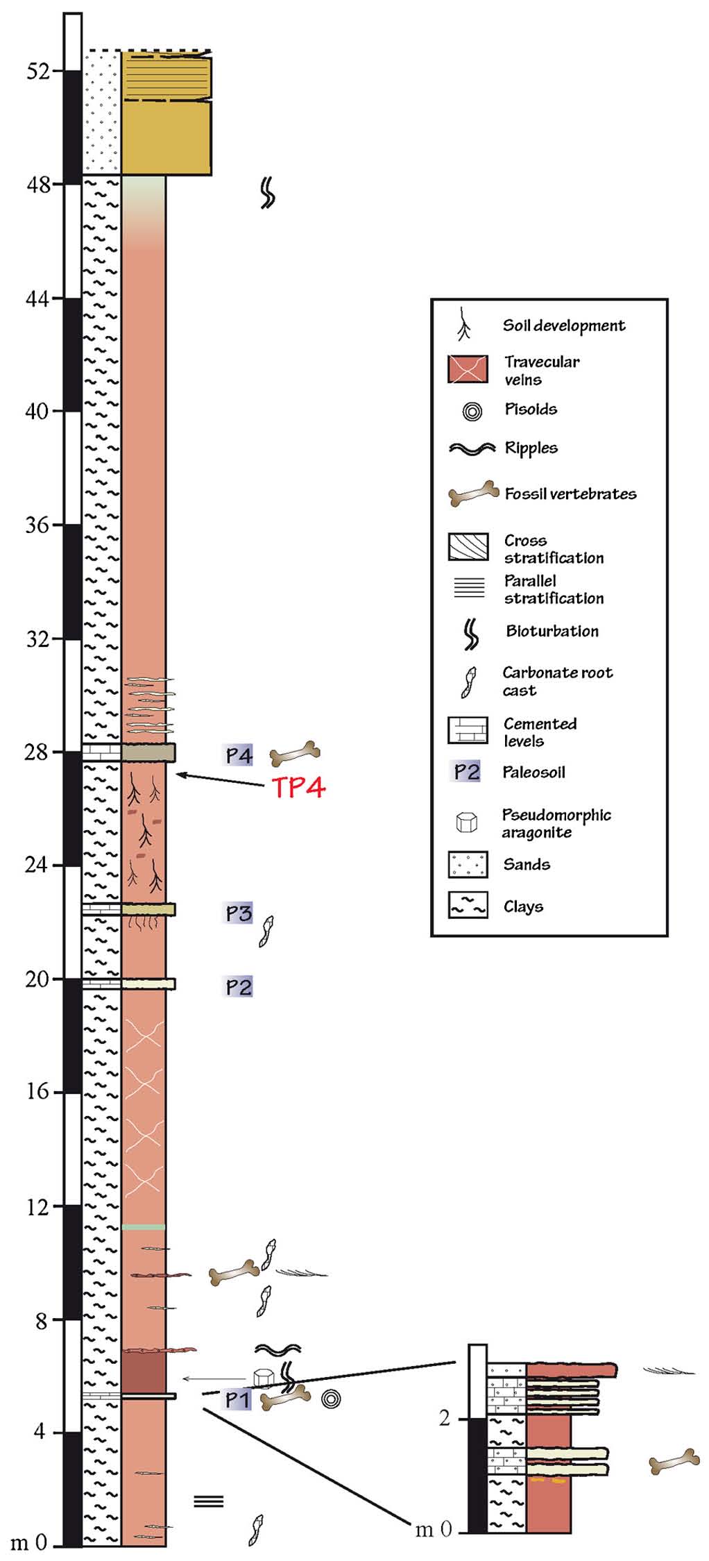
The Formation contains four paleosols, named stratigraphically, from the base to the top of the unit, P1 to P4 (Fig. 3) (Serrano-Martínez, 2015). The upper part of these calcareous paleosols is silicified and capped by a cherty crust. Bioturbation is present within the paleosols and becomes more dominant at the top of the Formation.
Paleosol 1 (P1) is characterized by the presence of pisolithic levels with vertebrate remains. It is not persistent laterally and grades into mudstones with white calcareous siltstone to sandstone intercalations 2 m thick.
Paleosol 2 (P2), compared to P1, is a well-developed paleosol containing carbonate nodules, likely of pedogenic origin.
Paleosol 3 (P3) is composed of brown vuggy carbonates that are 40 cm thick, often showing vertically oriented structures related to bioturbation or attributed to the effect of roots and pedogenic nodule formation. A carbonated crust caps the uppermost layer of this paleosol.
Paleosol 4 (P4) is calcareous siltstone of varied coloration (from red to green) and gradually grades vertically into mudstones.
Thickness: At least 52 m (Fig. 2 and Fig. 3)
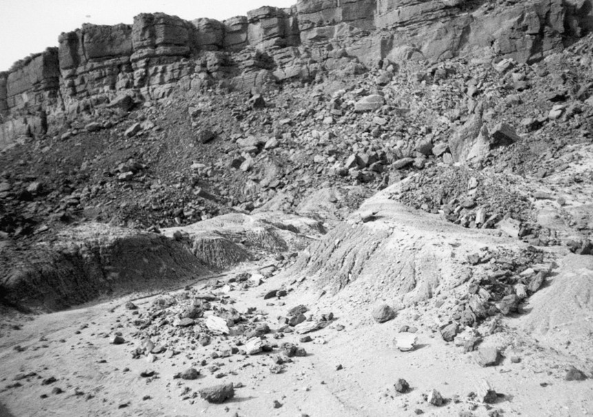
[Figure 1. Fine-grained sediments of the Tiouraren Fm (foreground) exposed in badlands near Marandet, and massive, coarse-grained sandstones of the lowermost unit of the Tégama Gr, the Tazolé Fm (background), forming the “Falaise de Tiguidit”, demonstrating the marked change in sedimentation between these two units. (Rauhut & López-Arbarello, 2009).]
[Figure 2. Graphic log of the Tiouraren Fm at Izak, near In-Gall (Source: Moody et al., 1991).]
[Figure 3. Stratigraphic section of the uppermost part of the Tiouraren Formation (Source: Serrano-Martínez et al., 2015).]
Relationships and Distribution
Lower contact
Underlain by the Irhazer Fm of the Irhazer Gr
Upper contact
Overlying Unit: Tazolé Fm of the Tégama Gr. Although no clear angular unconformity exists between the Tiouraren Fm and Tazolé Fm, the base of the Tégama Gr undoubtedly has an erosional contact with the underlying Tiouraren Fm.
Regional extent
The Tiouraren Fm is exposed in central Niger, south-west and south of the city of Agadez (Fig. 1).
GeoJSON
Fossils
Dinosaurs (Theropod Spinostropheus gautieri in association with the sauropod Jobaria tiguidensis (Sereno et al., 1999) and basal tetanuran Afrovenator abakensis (Sereno et al., 1994 and Sereno et al., 2004). Dinosaur tracks, crocodiles, fishes (Hybodus, Lepidotes, Asiatoceratodus tiguidensis, Mawsonia lavocati) and invertebrates (Conchostracans, unionid bivalves) (Rauhut & López-Arbarello, 2009; Van Damme et al., 2015). Turtle egg (Web-04)
Age
Depositional setting
Continental. Low-energy environment with low relief and extensive floodplains, ephemeral lakes and meandering rivers (Moody & Sutcliffe, 1991), a view that is reinforced by the fact that many of the sandstone channels consist of interformational sandstones, i.e. reworked sand-sized pebbles of mudstone.
Additional Information